As of January 2004 au.riversinfo.org is archived under Precision Info
RIVERSINFO AUSTRALIA ARCHIVE
This archive provides non stylised versions of selected reference documents (formerly) resident on au.riversinfo.org.
Reproduced (scanned) from a leaflet supplied with
National River Health Program (2000)
Community Information Unit
Department of the Environment and Heritage
GPO Box 787 CANBERRA ACT 2601 AUSTRALIA
Phone: +61 2 6274 1221 (in Australia: 1800 803 772)
See also: National Land and Water Resources Audit
Website: www.nlwra.gov.au
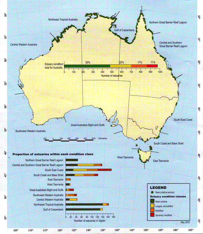
Shown by aggregated Interim Marine and Coastal Regions for Australia
This map illustrates the results of an initial qualitative condition assessment of 970 of Australia's estuaries. Near pristine estuaries are identified by a green dot.
The estuaries have been classified as near pristine, largely unmodified, modified, and severely modified. interim Marine and Coastal Regions for Australia have been aggregated on the basis of similar biophysical features.
The Near pristine estuaries map was produced by the National Land and Water Resources Audit in partnership with: Australian Geological Survey Organisation; CRC for Coastal Zone Estuary and Waterway Management; CSIRO; Environment Australla; Fisheries Research and Development Corporation; and the University of Queensland.
Published by the National Land and Water Resources Audit Canberra. © Commonwealth of Australia 2000.
The National Land and Water Resources Audit does not warrant this map is definitive or error free. The National Land and Water Resources Audit does not accept liability for any loss caused or arising from reliance upon information provided herein.
Coastline data provided by AUSLIG.
Map production by EarthWare Systems (Australia) Pty Ltd.
The first stage of the Australia-wide estuary condition assessment has made a preliminary classification of the condition of 970 estuaries in Australia. The estuaries that were classified as near pristine are the focus of this summary report.
This assessment broadly defines an estuary as a 'semi-enclosed coastal body of water where salt water from the open sea mixes with freshwater draining from the land'. The estuaries included in the assessment were selected according to management interest rather than a strict scientific definition.
Tides, waves and river flows are important physical processes that influence estuary estuary shape and ecology. Estuaries can be categorised into three types based on the relative dominance of these physical processes.
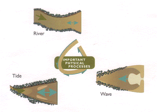
Each estuary type has distinct characteristics, susceptibility to impacts and management requirements. All Australian estuaries in this assessment are being classified according to their dominant biophysical processes. This classification will be used as a framework for management.
Near pristine estuaries are valuable as:
An estuary was classified as near pristine if it had:
The other three categories of the assessment-largely unmodified, modified and severely modified-display increasing levels of changes for some or all of these key criteria.
Most of Australia's near pristine estuaries are located away from population centres in tropical northern Australia and temperate western Tasmania. Important near pristine estuaries are also found around the developed areas of Australia, often within or near to managed public lands such as national parks and state forests.
Australian estuaries were found to be:
The near pristine estuaries map illustrates the results of the qualitative condition assessment of estuaries.
Estuaries from each of the States and Northern Territory reflect the diversity of the Australian landscape. In the following section of this brochure, values of near pristine estuaries from each region in Australia and issues for their management are briefly mentioned. The coloured bar represents the condition of all the estuaries in that State, and the number to the right of the bar and its relative length is the total number of estuaries in the State.
South Australia's rainfall is low; hence the majority of South Australian estuarine systems are tide-dominated. South Australia's major river-the Murray - has been regulated to meet development needs affecting downstream estuarine systems. Estuaries in this State are threatened by coastal development and commercial and recreational activities. Not only does this State have few estuaries in total, very few of those are considered to be near pristine.
Some estuaries in South Australia are more correctly identified as 'embayments'. These systems have important fisheries and conservation values. South Australia is undertaking a management-oriented inventory and it is likely that the embayments will be added to the Australian database.
The small wave-dominated estuary 'lagoon' at the mouth of Breakneck River on Kangaroo Island, is the only South Australian estuary whose catchment is totally included within a national park-the Flinders Chase National Park. The conservation role of this park is of prime importance in maintaining water quality. Visitors are encouraged to use and enjoy the area according to the principles and objectives set by the 1999 Flinders Chase National Park Management Plan.
Catchments in the west, north-west and south of Tasmania are characterised by high rainfall and run-off, while catchments in the cast and north-cast are relatively dry. North coast estuaries are tide-dominated barrier estuaries. They are open to the sea and have much greater tidal ranges than estuaries on the southern, eastern and western coasts. The cast coast and Bass Strait estuaries are intermittently closed by sand barriers and are therefore wave-dominated.
The majority of near pristine estuaries in Tasmania are located in the south and west of the State and on Cape Barren Island in the Furneaux Group. These estuaries are valued for nature conservation, wilderness and recreation.
Approximately 50% of near pristine estuaries in Tasmania are located in national parks. Although this partially protects their adjacent aquatic environments, further ways to protect aquatic life and other environmental values of these estuaries need to be developed to minimise threats. These threats include (but are not limited to):
Western Australia has a diverse range of estuaries.
Northern Western Australia has tidal ranges of more than 10 m and estuaries in this region are tide-dominated. Monsoonal rainfall also has a seasonally important influence on the ways these estuaries function. Extreme heat and evaporation cause stunted growth in estuary-associated vegetation such as mangroves, but little more is known about the natural processes driving these estuaries.
Near pristine estuaries in this area are important for cultural values, pearl aquaculture, commercial and recreational fishing, safaris, and eco-tourism.
Further research is needed to identify potential threats and to make specific recommendations on how to maintain and manage these estuaries in near pristine condition.
Central-northen and southern Pilbara estuaries are both wave and tide dominated.
Near pristine estuaries in this region are valued for nature conservation and eco-tourism. Eco-tourism needs to be well managed to maintain the values and condition of these estuaries.
The south-western and southern coasts of Western Australia have tidal ranges of 0.5-1 m and are wave-dominated. Some estuaries are seasonally closed and some remain permanently open. The Mediterranean climate and rainfall pattern in this region results in a floristically rich coastal heath and extensive forests in the wetter areas of the south-west corner.
Broke inlet at the mouth of the Shannon River is the only estuary in near pristine condition in this region. It is a large lagoon and is connected to the sea by a long, narrow channel through coastal dunes. The estuary is located entirely within the D'Entrecasteax National Park which extends along the coast.
Broke Inlet has many conservation values and is also important for recreational and commercial fishing. The inlet is geologically similar to many estuaries on the south coast, making it useful as a benchmark to compare with problems of nutrient enrichment and sedimentation within other inlets and estuaries.
The estuaries on the northern, Arnhem Land and Gulf of Carpentaria coasts are predominantly tide-dominated barrier estuaries, which vary greatly in size and floodplain characteristics. Tides range up to 7-8 m and freshwater input to all estuaries is strongly seasonal. Floodplain wetlands are associated with most large estuaries.
Northern Territory estuaries are valuable for traditional harvesting, eco-tourism, pearling, and commercial and recreational fishing. The Cobourg Marine Park (contiguous with Gurig National Park) protects the biologically diverse Cobourg Peninsula and includes many small estuaries.
Estuaries along the Gulf of Carpentaria, in addition to the above uses, also play an important role in supporting prawn and finfish fisheries. The number and diversity of near pristine estuaries in the Northern Territory provide reference sites and research opportunities to better understand modified tropical estuaries. The major estuaries on this coast provide significant habitat for one of the densest populations of saltwater crocodiles in the world, and roosting areas for sea and water birds.
Catchment and shoreline development can pose a threat to near pristine estuaries. Sediment loading to estuaries will increase if natural vegetation is not maintained.
Queensland has a long coastline containing many near pristine estuaries.
The Gulf of Carpentaria coast is flat with a large area of mangroves and salt pans which becomes a contiguous wetland complex during the wet season. The estuaries here are tidedominated.
Near pristine estuaries in the Gulf of Carpentaria provide essential nursery habitat for prawns and finfish, supporting major commercial, recreational and traditional fisheries. On-going management to ensure the sustainability of these fisheries is required. Other values are conservation of biodiversity, cultural uses and safari-based eco-tourism.
Cape York has mostly tide-dominated barrier estuaries interspersed with small wave-dominated estuaries. There are also some seasonally river-dominated estuaries.
Near pristine estuaries on Cape York are important for conservation of biodiversity. They support endangered and vulnerable biota such as turtles, dugongs, and crocodiles. Other important values include:
Eco-tourism, and commercial and recreational fisheries must continue to be well managed in order to protect the values of near pristine estuaries. Protection measures need to involve all stakeholders and become an integral part of the Cape York Peninsula Land Use Strategy.
Southern and central Great Barrier Reef lagoon coasts have a broad spectrum of river, tide and wave-dominated estuaries.
Near pristine estuaries are important resources that support commercial and recreational fisheries, and have recreation, nature-conservation and wilderness values.
The Great Barrier Reef Marine Park World Heritage Area, the Wet Tropics World Heritage Area, coastal and island national parks, and the Shoalwater Bay Military Training Area protect several small estuaries and their catchments. Seventy-five Fish Habitat Areas (protecting key areas of fish habitat) are also strategically distributed along the Queensland coast.
One of the few near pristine estuaries in south-east Queensland is located at the mouth of Baffle Creek. Although its catchment has high integrity; the estuary still needs management in order to maintain its near pristine values. Baffle Creek is currently under consideration as a Fish Habitat Area and it is expected that a formal declaration will be achieved by mid-2000.
Northern New South Wales has tide to river-dominated barrier estuaries with extensive floodplains, interspersed with a series of wave-dominated coastal creeks and lagoons. Many of these wavedominated systems have ephemeral entrances where longshore sand drift closes entrances between periods of high freshwater flow.
Several of the smaller estuaries (e.g. Lake Aragan with its ephemeral entrance lagoon, and Sandon River, a barrier estuary) are wholly within national parks. The central coast of New South Wales, while still containing barrier estuaries and lagoons, is noted for its drowned river valleys (e.g. in the lower Hawkesbury River, Sydney Harbour and Port Jackson).
Most of the estuaries of New South Wales are under intense land use pressure with approximately 80% of the State's population living near an estuary. Most of the State's estuaries are also considered modified as a consequence of this pressure and there are conflicts within local communities over the use of this limited resource. The NSW Estuary Management Program was introduced in 1992 to help resolve these conflicts and to provide technical and financial assistance to local governments, so that they could prepare and implement sustainable estuary management plans. The NSW Estuary Management Manual 1992 was compiled to assist managers to address critical estuary management issues. Sound estuary management has developed as a result of these initiatives.
On the northern coast, resolution of conflict over resource use has included debate over the management of acid sulfate soil runoff (which can result in fish kills), restoration of drained coastal wetlands, recreational boating and fishing, aquaculture and oyster farming, commercial fishing, sand extraction, and entrance shoaling.
The few remaining near pristine estuaries in southern New South Wales are generally located adjacent to or within land of public tenure (e.g. national parks or State forests). Their location away from areas of intense development pressure and on public land, means that most will be able to be sustainably managed into the future. These near pristine estuaries also provide important benchmarks for measurement of the condition of modified estuaries and in helping to design cost-effective remedial activities.
Key near pristine systems in southern New South Wales include Merool Willinga, Durras, Termeil, Nelsods and Nadgee lakes. Most of these lake systems have national park and State forest lands within their catchments and are managed for nature conservation as well as other uses. Many park boundaries do not specifically include associated or adjacent estuaries. However the values of these estuaries need to be recognised and managed as an ecologically important public resource.
Victoria has many small estuaries that are either river or tidedominated barrier estuaries, or small wave-dominated lagoons. The entrances to these estuaries are usually ephemeral. Two large embayments (Western Port and Port Phillip Bay) and the Gippsland Lakes (an interconnected lake system with an entrance to the coast) are also included in the assessment for management purposes.
Estuaries in western and central Victoria are modified to varying degrees by urbanisation, and industrial, agricultural and forestry activities in the adjoining catchments. Many of the small estuaries in eastern Victoria are located within national parks and are in near pristine condition. These estuaries are valuable as native conservation and wilderness areas.
Mallacoota Inlet is an estuary in near pristine condition that is being studied in detail to provide a benchmark for other more modified estuaries.
The current coastal management system is the cause of the failure to redress the problem of the coastline. This management system is characterised by fragmentation of responsibility between spheres of governments, among different professional areas of expertise, and across different social, economic and environmental interests. It is indeed difficult for the existing system of coastal management to become part of the solaution to coastal degradation while it remains part of the problem.
Valerie Brown, Centre for Resource and Environmental Studies Australian National University, 1995
Near pristine estuaries and their catchments require protection and careful management.
Catchment protection and management should ensure that land use does not deleteriously impact on waterways or estuaries. Estuary use also requires management including:
Regional planning is essential and provides the context for developing appropriate management arrangements in consultation with community and industry.
Restoration of an estuary and its catchment is expensive. Protective management is more cost-effective in the long term.
Lead agency for estuary management
Estuaries lie between the terrestrial and marine spheres of natural resource management. As a consequence their management has often been neglected. Overlapping responsibilities across tiers of government and agencies also make management complex. This is compounded by the various values held and uses demanded by the community.
A lead agency within each State, and attention to how the roles and responsibilities of all tiers of government and their agencies are accommodated, would facilitate improved estuary management.
Specific policy
In recent years, a range of initiatives at local, State and Commonwealth government levels have addressed the needs of waterways, coasts and oceans. An Australia-wide policy and management initiative for estuaries is essential.
The role, breadth and implications of such a policy will be explored as the assessment of Australia's multi-use, modified estuaries progresses.
Community and industry involvement
Government alone will not fulfil estuarine management needs. All natural resource management involves partnerships between community industry and government. However, community and industry demands on estuarine resources often compete and sometimes conflict. Processes and institutional arrangements that support community and industry involvement and action need to be built into all management activities.
The Australia-wide estuary condition assessment is now concentrating on gathering information and providing management recommendations for the more than 400 modified estuaries around Australia's coastline.
The Australia-wide database being collated by all States and the Northern Territory provides the framework for this assessment. Results of the process-based classification of estuaries will be included ... . Findings and recommendations will be complete by May 2001.
 Riversinfo Australia (au.riversinfo.org): Publication Information:
Current at December 2002
![]() au.riversinfo.org has been developed to facilitate public access to scientific and technical information on Australia's Rivers. Much of this material was paid for using public funds and is therefore owned by the Australian people. Environment Australia have been instrumental in making available all the publications from:
au.riversinfo.org has been developed to facilitate public access to scientific and technical information on Australia's Rivers. Much of this material was paid for using public funds and is therefore owned by the Australian people. Environment Australia have been instrumental in making available all the publications from:
 The au.riversinfo.org Internet site is in-part supported by the Natural Heritage Trust. The Natural Heritage Trust focuses on five key environmental themes - land, vegetation, rivers, coasts and marine, and biodiversity. The programs of the Natural Heritage Trust play a major role in developing sustainable agriculture and natural resource management, as well as protecting our unique biodiversity through improved management and delivery of resources.
 The au.riversinfo.org Internet site is in-part supported by Sydney Airport who have co-funded a Natural Heritage Trust supported project intended to develop Internet based environmental information integration and management systems. This will assist in developing an overall perspective on the demands and uses for environmental resources