As of January 2004 au.riversinfo.org is archived under Precision Info
RIVERSINFO AUSTRALIA ARCHIVE
This archive provides non stylised versions of selected reference documents (formerly) resident on au.riversinfo.org.
National River Health Program - Project E1
Digby, M.J., Saenger, P., Whelan, M.B., McConchie, D., Eyre, B., Holmes, N., and Bucher, D.
Centre for Coastal Management Southern Cross University
LWRRDC Occasional Paper 16/99 (Urban Subprogram Report No.9 1999)
Executive Summary, Acknowledgments, Abbreviations
Foreword & Publication Information
Chapter 3: Australian Estuarine Database (AED)
4. Physical Classification Model
This document is to be cited as:
Digby, M.J., Saenger, P., Whelan, M.B., McConchie, D., Eyre, B., Holmes, N., and Bucher, D. (1998) A Physical Classification of Australian Estuaries. Report prepared for the Urban Water Research Association of Australia by the Centre for Coastal Management, Southern Cross University, Lismore, NSW.
The objective of this study was to develop a national classification of Australian estuaries based on easily quantifiable biologically important physical characteristics. Using Microsoft Access v. 7.0., an Australian Estuarine Database (AED) was compiled incorporating spatial, geographic, morphological and climatic data for 780 estuaries. The AED was subsequently analysed statistically (SPSS v. 9.5.1.) to identify a physical classification model that would explain as much of the variability as possible in the proportion of mangroves and saltmarshes in the estuaries. Mangrove and saltmarsh proportions were used because these biological parameters are easily measured and because mangroves and saltmarshes are present in many estuaries and are more or less stable on a seasonal basis and inter-annually. In the final classification, estuaries were first classed into five groups based on climate (tropical, tropical savannah, hot dry, subtropical, temperate). These classes were further divided into 15 groups based on tidal range (low, medium, high). of the 15 groups 11 contained estuaries. For further classification purposes, all estuaries with a mid- or high-tide range were further sub-divided using the second level classifiers of the intertidal proportion to result in 23 classes of which 21 contained estuaries. The final classification model explained 44.5% and 42.5% of the variation in mangrove and saltmarsh proportions respectively and, as such, it provides a methodology by which biologically-important physical factors were identified.
| AED | Australian Estuarine Database |
| BoM98 | Climatic scheme developed by the Bureau of Meteorology in 1998 |
| BoM81 | Climatic scheme developed by the Bureau of Meteorology in 1981 |
| Cv | Coefficient of variation of flow |
| DDRs | Drought dominated regimes |
| FDRs | Flood dominated regimes |
| FF | Fluvial flow |
| FFcat | Categorised fluvial flow |
| IBRA | Interim Biogeographic Regionalisation of Australia |
| IMCRA | Interim Marine and Coastal Regionalisation of Australia |
| ITP | Intertidal proportion |
| ITPcat | Categorised intertidal proportion |
| MDL | Main drainage line/s |
| PM | Mangrove proportion |
| PSG | Seagrass proportion |
| PSM | Saltmarsh proportion |
| TDL | Terminal drainage line/s |
| TR | Extreme tidal range |
| TRcat | Categorised extreme tidal range |
| UWRAA | Urban Water Research Association of Australia |
This report describes the outcomes of a research project conducted under the Urban Research and Development sub-program of the National River Health Program (NRHP).
The NRHP is an on-going national program established in 1993, managed by the Land and Water Resources Research and Development Corporation (LWRRDC) and Environment Australia. Its mission is to improve the management of Australia's rivers and floodplains for their long-term health and ecological sustainability, through the following goals:
Urban streams and estuaries (i.e. those affected by runoff and discharges from urban areas) are an important subset of Australia's waterways. Most are degraded biologically, physically and chemically and therefore require appropriate methods to be developed for health assessment and management. The Urban R&D Sub-program, managed by the Water Services Association of Australia, comprises 8 research projects which were developed to meet research priorities for urban streams and estuaries within the goals of the NRHP and to complement existing NRHP projects on non-urban rivers. Thus, research focuses on development of standardised methods for assessing the ecological health of urban streams and estuaries which can be linked with data on water and sediment quality. The urban R&D projects commenced in 1996.
The definition of health in urban waterways used is "the ability to support and maintain a balanced, integrative, adaptive community of organisms having a species composition, diversity and functional organisation as comparable as practicable to that of natural habitats of the region".
The eight projects of the Urban Sub-Program are:
| Decision support system for management of urban streams | Dr John Anderson Southern Cross University, Lismore |
| RIVPACS (River InVertebrate Prediction and Classification System) for urban streams | Dr Peter Breen CRC for Freshwater Ecology, Monash University, Melbourne |
| DIPACS (Diatom Prediction and Classification System) for urban streams | Dr Jacob John Curtin University, Perth |
| Sediment chemistry- macroinvertebrate fauna relationships in urban streams | Dr Nick O'Connor Water EcoScience, Melbourne |
| Classification of estuaries | Dr Peter Saenger
Southern Cross University, Lismore |
| Literature review of ecological health assessment in estuaries | Mr David Deeley Murdoch University, Perth |
| Estuarine health assessment using benthic macrofauna | Dr Gary Poore Museum of Victoria, Melbourne |
| Estuarine eutrophication models | Dr John Parslow CSIRO Marine Laboratories, Hobart |
Published by:
Land and Water Resources Research and Development Corporation
GPO Box 2182 Canberra ACT 2601
Telephone: (02) 6257 3379
Facsimile: (02) 6257 3420
Email: public@Iwwrrdc.gov.au
WebSite: www.lwrrdc.gov.au
© LWRRDC
Published Electronically on au.riversinfo.org by the Environmental Information Association (Incorporated) with the permission of LWRRDC and Environment Australia. Environment Australia assisted by providing copies of the manuscript for electronic publication. The Natural Heritage Trust provided project funds which were used to assist in publishing this material. In the case of variation between this document and the hard copy original the original takes precedence. (Bryan Hall).
Disclaimer:
The information contained in this publication has been published by
LWRRDC to assist public knowledge and discussion and to help improve the
sustainable management of land, water and vegetation. Where technical information
has been prepared by or contributed by authors external to the Corporation,
readers should contact the author(s), and conduct their own enquiries,
before making use of that information.
Publication data:
Digby, M.J., Saenger, P., Whelan, M.B., McConchie, D., Eyre, B., Holmes, N., and Bucher, D. (1998) A Physical Classification of Australian Estuaries. Report prepared for the Urban Water Research Association of Australia by the Centre for Coastal Management, Southern Cross University, Lismore, NSW.
Report No 9, LWRRDC Occasional
Paper 16/99.
ISSN 1320-0992
ISBN 0 642 26766 9
Managing Agencies
The need for practical estuarine classification schemes as resource management tools is becoming more apparent as development, population growth and pollution in the coastal zone increase the pressure on estuarine systems worldwide (Bucher & Saenger, 1991; Saenger, 1995). In order to properly conserve and manage estuarine resources across their entire spectrum, a comprehensive understanding is needed of the geomorphic and hydrological processes occurring in estuaries, together with their effect on estuarine ecology. Various schemes have been developed to aid the recognition of different estuary types, simplify their description and make possible the transfer of knowledge between estuaries with similar characteristics.
In a review of estuarine classification schemes, Ferguson (1996) described the different approaches used in estuarine classification around the world, and highlighted some of the key aspects of Australian estuaries that should be considered when developing a biologically relevant physical classification scheme (Table 1). Most existing classification schemes have focused on geomorphic and/or hydrologic conditions without considering their effect on habitat types and ecology, and very few have included any reference to the evolutionary stage (or maturity) of estuaries which influences both estuarine hydrology and ecology (Roy, 1984).
| Table 1 Criteria used for the classification of estuaries. | |
|---|---|
| Classification type | Criteria |
| Geomorphology |
|
| Evolutionary stage |
|
| Hydrological processes |
|
| Climate |
|
| Water quality |
|
| Habitat |
|
| Land use |
|
| Aesthetic |
|
| Source: Ferguson (1996) | |
The objective of this research program was:
The underlying rationale (as provided by UWRAA) is as follows:
The scope of the project was defined as follows:
Estuaries at all stages of evolution can be recognised along Australian coastlines (Roy, 1984). Evidence of the post-glacial marine transgression that began about 17,000 B.P. is well documented in Australia, with most examples from the east coast (eg. Thom & Chappell, 1975; Thom et al., 1978; Grindrod & Rhodes, 1984; Pye & Bowman, 1984; Thom et al., 1992;) and more limited evidence from the other coasts (Woodroffe et al., 1986). Sea level rise is considered to have been fairly uniform around the Australian coast as a result of the tectonic stability of the continent and the absence of extensive glacial ice cover (Woodroffe et al., 1989). However, the exact course of sea level change varied slightly between different parts of Australia (Thom & Chappell, 1975) giving rise to variations in estuary processes and development.
Australia has a generally low coastal relief due to tectonic stability, prolonged erosion, low river discharges and the absence of glacial valleys. Hence, extensive drowned river valleys are poorly represented, with most occurring on the NSW central coast - Karuah River (Port Stephens), Hawkesbury River (Broken Bay), Parramatta River (Port Jackson), Georges River (Port Hacking), and some in Tasmania - Derwent River, Old River (Bathurst Harbour). The predominance of shallow barrier estuaries around the southeast and southwest coasts is probably due to prevailing wave regimes, longshore littoral processes and low river discharges (Hodgkin & Hesp, 1998). In areas of exceptionally low discharge, estuary entrances are either periodically closed to the sea (eg. the Murray River mouth, S.A.) or permanently closed.
Along the Timor and Gulf of Carpentaria coasts a low energy wave environment and a high tidal range have created a drowned coastline characterised by numerous macrotidal estuaries with deltas rather than barrier structures at their mouths. Infilling along this coastline has been extensive (Woodroffe et al. 1989). Low coastal relief in many parts of Australia commonly results in small coastal catchments.
Australia is the most arid populated continent in the world and in terms of river discharge, has no world class rivers. Discharge from the Fly, Kikori and Purari Rivers in Papua (>40 * 1010 m3 yr-1) exceeds the total river discharge in Australia (~30 * 1010 m3 yr-1). Rainfall and river discharges in the different Australian coastal regions are summarised in Table 2. Low, erratic rainfall patterns over much of the country combined with small coastal catchments and high evaporation rates mean that annual discharges form Australian rivers are the lowest and most variable in the world (McMahon, 1982).
| Table 2: Distribution of estuary types in Australia. | |||||
|---|---|---|---|---|---|
| Timor Sea: Regional area 539 000 (km2) | |||||
| Annual rainfall (mm) |
Total Runoff (*1010 m3) |
Tidal range variation (m) |
Dominant morph. estuary type1 | Seasonal mixing regimes2 | |
| 600-1200 summer maximum |
0.138 | 2.0 - 10.5 | Macrotidal drowned river valleys, mature | Dry: Inverse estuary; Wet: short lived freshwater flushes |
|
| Gulf of Carpentaria: Regional area 640 800 (km2) | |||||
| Annual rainfall (mm) |
Total Runoff (*1010 m3) |
Tidal range variation (m) |
Dominant morph. estuary type1 | Seasonal mixing regimes2 | |
| 600-1600 summer maximum |
0.099 | 2.2 - 7.7 | Macrotidal drowned river valleys, mature | Dry: Inverse estuary; Wet: short freshwater flush may occur |
|
| Northeast Coast: Regional area 454 000 (km2) | |||||
| Annual rainfall (mm) |
Total Runoff (*1010 m3) |
Tidal range variation (m) |
Dominant morph. estuary type1 | Seasonal mixing regimes2 | |
| 800-4000 summer maximum |
0.183 | 1.6 - 6.3 | Barrier, drowned river | Dry: Well mixed Wet: Highly stratified during high river flows |
|
| Southeast Coast: Regional area 268 000 | |||||
| Annual rainfall (mm) |
Total Runoff (*1010 m3) |
Tidal range variation (m) |
Dominant morph. estuary type1 | Seasonal mixing regimes2 | |
| 600-1600 mixed |
0.136 | 1.1 - 1.8 | Barrier, drowned river | Well mixed, short periods of stratification after flood events | |
| Tasmania: Regional area 68 400 (km2) | |||||
| Annual rainfall (mm) |
Total Runoff (*1010 m3) |
Tidal range variation (m) |
Dominant morph. estuary type1 | Seasonal mixing regimes2 | |
| 600-3200 mixed |
0.690 | 0.9 - 2.5 | Drowned river | Salt wedge | |
| South Australian Gulf: Regional area 75 370 (km2) | |||||
| Annual rainfall (mm) |
Total Runoff (*1010 m3) |
Tidal range variation (m) |
Dominant morph. estuary type1 | Seasonal mixing regimes2 | |
| 300-800 winter maximum |
0.007 | 0.5 - 2.0 | Barrier | No data available | |
| Southwest Coast: Regional area 140 000 (km2) | |||||
| Annual rainfall (mm) |
Total Runoff (*1010 m3) |
Tidal range variation (m) |
Dominant morph. estuary type1 | Seasonal mixing regimes2 | |
| 400-1200 winter maximum |
0.052 | 0.4 | Barrier | Dry: Highly stratified, increasingly saline Wet: Freshwater flush |
|
| Indian Ocean: Regional area 520 000 (km2) | |||||
| Annual rainfall (mm) |
Total Runoff (*1010 m3) |
Tidal range variation (m) |
Dominant morph. estuary type1 | Seasonal mixing regimes2 | |
| 200-400 arid |
0.012 | 0.5 - 5.8 | Drowned river | Permanent inverse circulation | |
|
Sources:1. Interpolation from Bucher & Saenger, (1989); 2. Interpolation from: Rochford (1951); Hodgkin & Lenanton (1981); Thomson & Godfrey (1985); Wolanski (1986); Edgar & Cresswell (1991); Eyre & Twigg (1997). (Table layout changed in electronic version - B Hall ) |
|||||
Discharges during peak flood events relative to mean annual runoff are an order of magnitude larger in Australia than elsewhere in the world, and floods in most catchments are brief because many catchments are small and high rainfall periods are brief. Australia�s east coast also experiences long-period variation in rainfall, with alternating flood-dominated regimes (FDRs) and drought-dominated regimes (DDRs) persisting for periods of up to 50 years (Erskine and Warner, 1978). During FDRs, the frequency of flooding, and hence, the flushing of estuaries, dramatically increases. Australian estuaries, therefore, are characterised by a low freshwater input throughout most of the year, with short-lived, high energy flood events during wet seasons. Superimposed on this seasonal variation are the long-period oscillations of FDRs and DDRs.
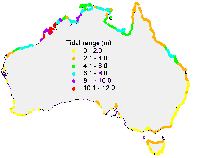
The Australian coastline experiences the full range of tidal environments, from the macrotidal northern regions to the practically atidal southwest (Figure 1). On the east coast, tides range from 6 metres in Queensland to less than 2 metres along the NSW and Victorian coasts (Table 2).
Tide range has been a major factor in creating distinctive Australian estuarine environments. Along the eastern coast, mixing caused by the dominance of tidal flow over river flow results in the characteristically well mixed estuaries of this region (Rochford, 1951). The absence of tidal mixing, due to small tidal range characterises estuaries in southwestern Australia; a small (60 cm) weekly meteorological tide is superimposed on the astronomical tide in this region of Australia. Shallow entrance bars in many estuaries in the southwest attenuate the astronomical tides and reduce tidal mixing to a minimum. In contrast, the macrotidal conditions had a major influence on estuarine morphology along the northern coasts.
|
| Figure 1. The geographical distribution of extreme tidal range of Australian estuaries. (enlargement) |
The extreme variation in river flow means that most Australian estuaries are characterised by distinctive wet and dry season mixing regimes. Well mixed estuaries on the east coast are subject to large flood events which completely flush the estuary and commonly push a freshwater plume into coastal waters (Davies and Kalish, 1994; Eyre, 1994; Eyre & Twigg, 1997). As freshwater flow decreases a salt wedge develops followed by a return to well mixed saline conditions. In the drowned river estuaries of the central NSW coast, short lived, high freshwater flows can form an overlying surface layer with minimal salt wedge development. Mixing of this layer is minimal because it is unaffected by tidal turbulence (Wolanski, 1977).
Stratification is much more strongly developed in Tasmanian estuaries (Table 2) due to relatively high runoff and low tidal action (Thomson & Godfrey, 1985; Edgar and Cresswell, 1991; Davies and Kalish, 1994). High freshwater flows during winter do not usually flush the estuaries but depress the halocline to greater depths in the water column.
In the barrier estuaries of southwestern Australia, small tides, shallow embayments and constricted entrances, low and variable river flows and high evaporation rates are all important factors determining mixing regimes. The intrusion of a bottom layer of sea water into estuaries under the influence of a wind-induced isostatic head, causes sharp stratification at the beginning of summer. Evaporation increases during summer and estuarine waters become hypersaline, reaching concentrations of up to 50 � (Hodgkin & Birch, 1982). Hypersaline conditions are exacerbated by small entrances and may continue until winter, when the estuary is flushed with freshwater; during winter salinity may decrease to 5� .
Unlike estuaries in the southwest, the Swan River estuary is relatively deep (up to 20 metres) and is well mixed in summer. A sill at the entrance inhibits the exchange of bottom water which becomes stagnant and anoxic. Freshwater flows in winter can fail to flush this stagnant water if discharge is too low.
Macrotidal estuaries in northern Australia exhibit classic inverse circulation during the summer when the estuary is essentially cut off from the sea resulting in the formation of a hypersaline barrier system. During floods a salt wedge is formed, but the penetration of freshwater downstream is retarded by the large tidally induced flow reversal; as the flood recedes, the salt wedge fades and the salt/freshwater interface moves upstream.
Most recently, Eyre (1998) classified Australian estuaries into five broad groups according to their hydrology and meteorology (i) Mediterranean: those dominated by winter floods and summer drought, (ii) Temperate: those that lack a well defined seasonal variation in flow, (iii) Transitional: those that lack a well defined seasonal variation in flow, but are significantly affected by winter storms, (iv) Arid Tropical/Subtropical: those where evaporation exceeds freshwater input and (v) Wet and Dry Tropical/Subtropical: those dominated by summer floods and winter drought.
There are about 80 of these estuaries found in the south-west of Western Australia. Mediterranean estuaries in Australia are typified by episodic freshwater supply during winter, a shallow water column, possible hypersalinity during summer, and restricted exchange with the ocean (flushing). Eighty percent are bar-built estuaries, which are seasonally-closed and as such have no exchange with the ocean for part of the year. Freshwater input is dominated by winter floods which produce intense stratification, but is not usually sufficient to flush all saltwater from the estuaries. Exceptions are some of the shallow bar-built estuaries and coastal lagoons found in the south of Western Australia (e.g. Torbay); because the tidal range is low, these estuaries recover very slowly, and stratification usually persists for extended periods. Persistent stratification may result in deoxygenation of the water column in deeper sections of some estuaries. Limited flushing means that a large portion of terrestrial material is retained within the estuary and consequently, these systems have been particularly susceptible to nutrient enrichment associated with inappropriate land use in the adjacent coastal catchments.
Temperate estuaries account in total for about 12% of Australia's estuaries, and are found in Tasmania, Victoria, South Australia and southern New South Wales. There is no distinct seasonal difference in freshwater input to these systems, although flows generally increase in late winter and may peak in spring due to snow-melt. Hydrologically, these estuaries most closely resemble North American and West European estuaries. Because there is a reasonably constant freshwater supply they are typically stratified for much of the year, and this stratification may intensify during increased spring runoff. The coefficient of variation of flow (Cv) for rivers in Tasmania are similar to the average values for rivers in North America and Europe. Flood conditions do not flush the estuary with freshwater, but simply increase the depth of the halocline.
Many of Australia's drowned river valleys (e.g. Karuah; Port Stephens; Hawkesbury River: Broken Bay; Parramatta River: Port Jackson; Georges River: Port Hacking) are represented in this group, and are geomorphologically similar to typical North America and West Europe systems. Several semi-enclosed estuaries (lagoons) are also found in this transitional zone. This group of estuaries accounts for about 5% of Australia's estuaries. They are dominated by winter storms and probably only become stratified immediately following storm events. Short-lived intense rainfall events generate buoyant freshwater plumes that may extend offshore as a brackish plume. However, because of the short-lived nature a salt wedge is not developed and the plume usually breaks down quickly due to large tidal ranges. Because of their poorly flushed nature, the semi-enclosed estuaries are particularly susceptible to pollution from sewage discharges and urban runoff.
There are 51 of these estuaries found in Western Australia between latitudes 17oS and 30oS, accounting for 6% of Australia's estuaries. The region receives low rainfall (200 to 700 mm year-1) and the catchments have very low runoff coefficients (0.01 to 0.06). The rivers typically only flow during and immediately after major storms and cyclones that may only occur every few years. As such, the estuaries receive very little freshwater flow and have high evaporation rates, resulting in permanent inverse estuaries where salinities exceed the salinity of adjacent seawater (e.g. Shark Bay). Shark Bay has very low net production due to low delivery of nutrients to the system. Inverse estuaries in Australia are not restricted to Western Australia, due to the arid nature of the continent (e.g. Spencer Gulf).
There are 534 of these estuaries found in northern New South Wales, Queensland, the Northern Territory and northern Western Australia. Accounting for approximately 68% of Australia's estuaries, they could be considered "typical Australian Estuaries". These systems are dominated by episodic short-lived large freshwater inputs during summer and very little or no flow during winter; these characteristics impact significantly on their hydrology, salinity structure and biology.
Under high flows salt water may be flushed completely or almost completely, out of the wet and dry tropical and subtropical estuaries. Although flushing fresh to the mouth appears to be common for wet and dry tropical estuaries, Australian wet and dry tropical and subtropical estuaries are shallow, due to tectonic stability and relatively low coastal relief, and exhibit extreme flooding behaviour. This observation suggests that flushing may occur more regularly in Australian systems than is currently recorded, but is often missed due to its short-lived nature.
Following a flushing event, the estuary would recover rapidly due to a large tidal range, as a salt-wedge intrudes along the channel bottom. It would then progress from a highly stratified salt wedge estuary, through a partially mixed estuary with a well developed two layered circulation, to a vertically homogeneous estuary. The extreme of this type of range is illustrated by some northern Australian estuaries, for example, Coral Creek, Dickson Inlet (Wolanski, 1992). During the wet season they flush fresh to the mouth, but because of low discharge and high evaporation rates during the dry season, an inverse circulation may develop. In these estuaries a salinity maximum zone often forms landward of the mouth and effectively isolates the estuary from coastal waters for several months of the year.
Most nutrients, pollutants and sediments flow into the estuaries during flood events where river discharge is high (Woodroffe et al., 1986; Arakel et al., 1989; Eyre & Twigg, 1997). For example, 80% of the phosphorus lost from agricultural land occurs in peak flow events and nitrogen shows similar trends (Brodie, 1995). On the east coast, where flood events are large enough to push freshwater plumes out to sea, much of the nutrient, pollutant and sediment load transported by rivers will pass straight through estuarine systems with little or no processing (Eyre & Twigg, 1997).
Under natural conditions before anthropogenic disturbances such as land clearing, cultivation and fertilisation, the effects of this wet season flush into coastal waters may have been less significant because phosphorus levels in Australian soils are low. Since the introduction of western agriculture, it is estimated that fluvial inputs of sediment, phosphorus and nitrogen have increased fourfold (Brodie, 1995).
Most of the year, during low freshwater flows, residence times are long and chronic inputs of pollutants and nutrients from point sources (eg. sewerage outfalls) tend to stay in the system for long periods leading to eutrophication as evident in the Peel Harvey estuary in Western Australia (Hodgkin & Birch, 1982). The trapping of large bodies of anoxic water behind raised entrance sills in the Swan River (Hill et al., 1990) and the South West Arm of Port Hacking (Bulleid, 1983) also has implications for the nutrient status of the estuary because it can limit biological productivity (and therefore bio-uptake of nutrients), and the availability and speciation of metals and nutrients within the estuary (eg. phosphorus becomes increasingly available at low dissolved oxygen concentrations). The cumulative effects of these dry season processes influence estuarine conditions until the wet season freshes, or the surface temperatures decrease and stratification breaks down.
Eyre (1998) presents a three stage model to illustrate the effect of seasonal extremes on the processing of material in wet and dry tropical/subtropical Australian estuaries.
During floods the salt intrusion is pushed back through the mouth of the estuarine basin, estuarine processes are by-passed and freshwater, sediment and nutrients are discharged directly onto the continental shelf. This process is unlikely to occur in most temperate Australian estuaries, and only a buoyant freshwater plume will probably escape the river mouth of transitional estuaries. Floods will probably only briefly depress the salinity of arid tropical/ subtropical Australian estuaries, but if the flood is sufficiently large, the estuarine basin may remain fresh at the mouth for several days. In contrast, even if just a small part of the salinity gradient remains within the mouth of the estuarine basin there may be significant deposition and processing of material within the estuary. The flushing time of an estuary is an important determinant of the quantity of nutrients retained. Because most sediment and nutrients from non-point sources are delivered to wet and dry tropical/subtropical estuaries during floods when they are rapidly flushed from the system, these estuaries usually have a low nutrient retention efficiency.
Following large floods, or during small floods, the estuary goes through a recovery stage where it progresses from a highly stratified salt wedge estuary, through a partially mixed system with a well developed two layer circulation, to a vertically homogeneous system. This sequence of events is mainly restricted to wet and dry tropical/ subtropical estuaries, because although Mediterranean estuaries go through a recovery period following freshets, recovery is very slow due to small tidal ranges. Most temperate Australian estuaries recover with a shallowing of the halocline, and transitional estuaries have no recovery stage because the buoyant freshwater plume simply dissipates very quickly.
Immediately following floods, some of the sediment from the sediment-laden upper layer settles through the halocline at slack water where it is caught in the lower layer, transported landward, and deposited near the salt/freshwater interface. The amount of material trapped depends on the flushing time of the estuary. Early on in the recovery stage both dissolved and particulate material passes through relatively conservatively due to short flushing times, but the processing of material increases with an increase in flushing time.
This stage represents normal conditions where the estuary has returned to a vertically homogeneous system that reflects very low or no freshwater discharge conditions. Very long flushing times typify this stage and hence, most of the river supplied material is transformed during this stage and very little escapes to the continental shelf; there may even be net landward transport of material with input from the ocean. The lack of a stable two-layered circulation means that the geochemical and biological reaction zones seen in temperate North American and West European estuaries are not represented in the same way. Instead of a distinct turbidity maximum at the salt/ freshwater interface, some of Australia's estuaries have high turbidities that extend over a much larger portion of the estuary. This can be seen in the subtropical Brisbane, Mary and Logan estuaries in south-east Queensland and has the effect of moving the biological reaction zone toward the mouth of the estuarine basin or maybe even further offshore.
Morphology and entrance conditions can be used to divide Australian estuaries into 4 basic types:
The dominant types are barrier estuaries and drowned river valleys. Saline lakes are similar to barrier estuaries because they form behind a coastal barrier system, but low fluvial inputs result in a permanent closure of the entrance; water in coastal saline lakes is saline to brackish but non tidal (Bird, 1984).
Chapman et al. (1982) and Roy (1984) have put forward several models describing the geomorphology and evolution of these estuarine types along the NSW coast (Tables 3 - 5). In the absence of any such descriptions of estuarine evolution in southwestern Australia and Victoria, it is reasonable to apply these models but local variations in geomorphology, river discharge and tide must be taken into consideration. Additionally, it is noted that all the listed estuary types could exist in a macrotidal setting and where this is applicable all other characteristics may be overprinted by tidal signatures.
| Table 3. Drowned river valley estuary model. | |||
| Morphological evolution | Entrance conditions | Tidal behaviour | Depositional environments |
|
Youth Deep, narrow Paleo-valleys with steep rocky sides with a shallow, tidal delta sill |
Permanently open, depth usually <10 metres |
Estuary strongly tidal with little attenuation. |
Mud basins dominate with a fluvial delta upstream and a tidal, marine delta at the mouth |
|
Intermediate Channel becomes increasingly infilled. Shallow water and intertidal environments form around expanding delta front in middle estuary |
Permanently open, tidal delta tends to migrate landwards |
Still tidally dominated in middle and lower estuary, tides attenuated in upper reaches as channel is infilled |
As upper estuary is infilled floodplains and levees develop. Fluvial delta progressively infills middle estuary |
|
Mature Channels become increasingly infilled and constricted by levee banks |
Permanently open, offshore delta may form. |
Lower and middle reaches still tidally dominated, with increasing attenuation in upper reaches |
Intertidal environments restricted to lower estuary. Fluvial sediment discharged at estuary mouth either lost to coastal sediment budget or reworked into prograding shoreline deposits adjacent to mouth. |
| Source: Chapman et al. (1982) and Roy (1984) | |||
| Table 4. Barrier estuary model. | |||
| Morphological evolution | Entrance conditions | Tidal behaviour | Depositional environments |
|
Youth Broad, shallow embayments separated from the sea by development of a coastal barrier. |
Usually constricted or periodically closed to the sea. Characterised by narrow, elongated entrance channels within broad tidal and backbarrier sand flats |
Tides are strongly attenuated by constriction at the river mouth. |
Infilling is mainly from fluvially derived sediments. Two dominant facies types are: basin muds and delta front sand muds. Infilling occurs from estuary head. |
|
Intermediate infilling with fluvial sediments creates lobate deltas with complex channel configurations |
Entrance becomes more channelised as intermediate reaches of the estuary are infilled. |
Tides are increasingly less attenuated and penetrate further upstream. |
Floodplains develop as infilling channelises the estuary. Increased mangrove areas associated with channel complexity trap fine fluvial sediments |
|
Maturity Deepened sinuous channel with smooth levee bank, |
Entrance deepened and permanently open, increased channelisation causes scouring during high flow events. |
Estuary becomes fully tidal. |
Floodplains become more extensive. Strong tidal flows mix fluvial and marine sediments may be lost offshore during high flow events or form deltas in low energy wave climates. |
| Source: Chapman et al. (1982) and Roy (1984) | |||
| Table 5. Macrotidal estuary model | |||
| Morphological evolution | Entrance conditions | Tidal behaviour | Depositional environments |
|
Transgression phase River valley inundated during later stages of Postglacial Marine Transgression creating classic drowned river. |
Open to sea, possibly tidal delta forms. |
Tidally dominated |
Infilling occurred throughout the estuary with estuarine sediments during dry season and fluvial sediments during the wet. |
|
Big Swamp phase As sea level stabilises, the river valley infills to become shallow intertidal shoals which are quickly colonised by mangroves creating a widespread swamp. |
Open to the sea. More than one main channel in lower estuary likely. |
Tidally dominated |
Large deposition of fine sediment (mangrove muds) |
|
Sinuous River phase Sinuous, meandering tidal river develops as swamp is succeeded by floodplain. |
Open to sea, funnel shape developed |
Tidally dominated |
Freshwater floodplain develops and shoreline progrades. |
|
Cuspate River phase Cuspate river bends succeeded sinuous meanders in upper estuary. Channel widens and becomes shallower with mid channel and point bar shoal development |
Open to sea, funnel shape maintained. |
Tidally dominated. Channel widening causes increased tidal flow and high tide levels upstream |
Minimal progradation of coastal plain. Old paleochannels are infilled while the river continues to meander. |
| Source: Chapman et al. (1982) and Roy (1984) | |||
A very successful consultative workshop with participants from various environmental agencies and research organisations was held at Southern Cross University on the 8-9 June 1996. The workshop aimed to:
From the workshop, the needs for a physical classification were identified and a listing of physical attributes that could be incorporated into the classification was compiled (Table 6)
| Table 6. A preliminary list of parameters to be considered for the classification scheme prepared by the workshop participants. | ||
|---|---|---|
| Data type # | Primary Parameter | Data type |
| Spatial | Total catchment area (km2) - A1 | Quantitative |
| Spatial | Total catchment landcover disturbance (km2) | Quantitative |
| Spatial | Floodplain area - 10 m contour (km2) - A2 | Quantitative |
| Spatial | Estuary area (km2) | Quantitative |
| Spatial | Estuary depth (m) | Quantitative |
| Spatial | Estuary length (km) | Quantitative |
| Spatial | Open water area (km2) | Quantitative |
| Spatial | Intertidal mudflat area (km2) | Quantitative |
| Spatial | Mangrove area (km2) | Quantitative |
| Spatial | Seagrass area (km2) | Quantitative |
| Spatial | Saltmarsh area (km2) | Quantitative |
| Evolution | Estuary maturity (A1 - A2) | Category |
| Geomorphic | Estuary mouth morphology | Category |
| Geomorphic | Catchment geology | Category |
| Hydrological | Tidal range (m) | Quantitative |
| Hydrological | Tidal period (time) | Quantitative |
| Hydrological | Stream discharge @ estuary | Volume: means, percentiles, cv |
| Hydrological | Stream discharge @ estuary | Height: means, percentiles, cv |
| Hydrological | Water temperature | means, max., min., cv. |
| Hydrological | Estuary flushing time | means, percentiles, cv. |
| Hydrological | Sediment clearance time | means, percentiles, cv. |
| Hydrological | Sediment load | means, percentiles, cv. |
| Hydrological | Sediment type | Category |
| Hydrological | Sediment source/parent material | Category |
| Oceanographic | Sea Surface Temperature (SST) | Coastal waters - means, percentiles, cv. |
| Oceanographic | Ocean swell direction | Category |
| Oceanographic | Ocean swell intensity | Category |
| Climatic | Estuary rainfall (mm) | means, percentiles, cv. |
| Climatic | Total catchment rainfall (mm) | means, percentiles, cv. |
| Climatic | Estuary Evaporation | means, percentiles, cv. |
| Climatic | Total catchment evaporation | means, percentiles, cv. |
| Climatic | Climate | Spatial classification |
The following are some additional issues that came out of the workshop:
In any final classification scheme, classifiers are multiplicative regardless of whether the classifiers are derived from binary, triangulation, clustering or other polythetic techniques. Consequently, the number of classes or compartments in the classification will increase factorially with the number of classifiers. Thus, two classifiers with three categories results in 9 classes; three classifiers each with three categories results in 27 classes; and four classifiers each with three categories results in 81 classes.
To be of practical use, the ultimate number of classes must be manageable and reflect the morphological and functional diversity of estuaries without establishing artificial or trivial boundaries.
The Australian Estuarine Database (AED) is derived from Bucher and Saenger�s - An Inventory of Australian Estuarine and Inshore Waters. The Bucher and Saenger inventory has been transferred from a Macintosh database format to Microsoft Access v.7.0. The database structure has been substantially modified, with the revision of some of the spatial data, and the inclusion of additional geographic and climatic data.
A summary of the data content of the AED is presented in Table 7. The revised and additional data are further described later in this section.
| Table 7. A summary of the data fields of the Australian Estuarine Database. | |
| Primary Database Field | Description |
| Record No | Unique database record reference number |
| Estuary ID | Unique identification number |
| Name | Name of estuar |
| State | State in which estuary lies |
| Estuary Type | Individual, or complex composite, or complex component estuary |
| Latitude | Latitude of estuary mouth |
| Longitude | Longitude of estuary mouth |
| Catchment area | Area of catchment draining into estuary (km2) |
| Open water area | Area of open waters within the estuary (km2) |
| Intertidal flats area | Area of intertidal sand and mud flats with the estuary (km2) |
| Mangrove area | Area of mangrove stands within the estuary (km2) |
| Mangrove cover | Subjective assessment of mangrove cover |
| Seagrass area* | Area of seagrass within the estuary (km2) |
| Seagrass cover* | Subjective assessment of seagrass cover |
| Saltmarsh area | Area of saltmarsh within the estuary (km2) |
| Saltmarsh cover | Subjective assessment of saltmarsh cover |
| Mean annual rainfall | Mean annual rainfall of the estuary (mm) |
| Runoff Coefficient | Mean annual runoff coefficient |
| Extreme tidal range | Extreme tidal range at estuary mouth |
| BoM98 | Climatic classification of the estuary derived by BoM 1998 |
| BoM81 | Climatic region of the estuary derived by BoM 1981 |
| Geographic Zone | Geographic region derived by ACIUCN 1986 |
| IBRA | Interim Biogeographic region of the estuary (Thackway & Cresswell, 1995) |
| IMCRA | Interim Marine and Coastal region of the estuary ( IMCRATG, 1997) |
| Landuse* | Subjective assessment of catchment development |
| Flood frequency* | Subjective assessment of flood frequency |
| Water quality* | Subjective assessment of water quality |
| Fisheries value* | Subjective assessment of fisheries value |
| Fisheries threat* | Subjective assessment of fisheries threat |
| Conservation value* | Subjective assessment of conservation value |
| Conservation threat* | Subjective assessment of conservation threats |
| Amenities* | Subjective assessment of amenity value |
| Ecological status* | Subjective assessment of ecological status |
| Literature* | Assessment of literature availability |
| Administration* | Statutory administrators |
| Mouth type | Single or multiple mouth |
| Mouth constriction | Constricted or unconstricted |
| Waterbody form | Branched or unbranched main drainage lines |
| Waterbody type | Channel or bay main drainage line |
| Embayment | Presence or absence of off-channel embayments |
| TDL | Single, dendritic, or single and dendritic terminal drainage lines |
| Fluvial flow (FF) | derived from |
| Intertidal Area (IA) | |
Intertidal Proportion (ITP) | |
Mangrove Proportion (PM) |
|
Saltmarsh Proportion (PSM) |
|
Seagrass Proportion (PSG) |
|
| Footnote: * These variables change over time or data collection is ongoing | |
Estuaries are defined as semi-enclosed bodies of water and adjacent wetlands which have input both from marine tidal inundation and terrestrial runoff.
To be included in the AED an estuary must meet following minimum criteria:
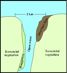
The seaward boundary of an estuary for the purposes of this project is at the point where the distance between two opposite banks (including any intertidal land) first narrows to a distance of less than 2 km when approached from seaward (Figure 2). Two kilometres is an arbitrary figure that not only sets the line of division between estuarine and marine environments. It simplifies deciding whether to treat two adjacent river mouths as a single estuarine system or as two separate estuaries.
 |
| Figure 2. Arbitrary boundary between marine and estuarine environments. |
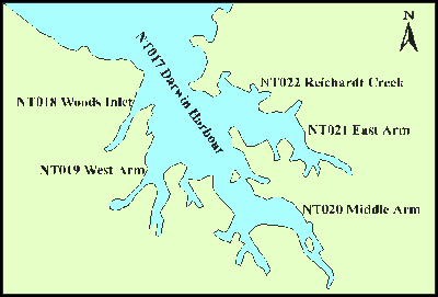
Composite estuaries are defined as - bodies of water that are sufficiently enclosed as to contain environments distinct from open coasts and more than one estuary can be identified within a marine water body. For example Darwin Harbour (Figure 3) is made up of five individual estuaries and as such is considered to be a composite estuary.
Individual estuaries which make up composite estuaries are referred to as component estuaries. Composite estuaries were not included in the classification but component estuaries were.
 |
| Figure 3. An example of a complex composite estuary and its component estuaries. (enlargement) |
The AED contains records for 780 estuaries around Australia. These include 22 composite and 758 component and individual estuaries (Table 8).
| Table 8. Number of individual and component estuaries contained in the AED. | ||
|---|---|---|
| State | Number | |
| New South Wales | 80 | |
| Victoria | 34 | |
| Tasmania | 58 | |
| South Australia | 15 | |
| Western Australia | 142 | |
| Northern Territory | 133 | |
| Queensland | 296 | |
| Total | 758 | |
Catchment area:
This field contains the estimated area (km2) of the catchment draining into the estuary. Catchment area was drawn from the literature or estimated from topographic maps for 386 estuaries in the original database (Bucher & Saenger, 1989). All estuaries in Victoria, New South Wales, Tasmania and 108 in Queensland, 32 in Northern Territory and 65 in Western Australia had catchment areas recorded. A digital elevation model was used to estimate catchment areas for the remaining estuaries.
Intertidal flats area:
This field contains the estimated area (km2) of intertidal sand and mud flats in the estuary. The area of intertidal flats was drawn from the literature or calculated from topographic maps. Intertidal recorded areas were available for all estuaries, except those in New South Wales, in the original Bucher and Saenger database; the intertidal area for New South Wales estuaries was estimated from 1:25000 topographic maps.
Runoff coefficient:
The runoff coefficient was calculated from rainfall. The runoff figure used is the best available approximation to a catchment average and is usually the average value for the respective drainage basin (from the Australian Water Resources Council, 1976 and Graddon, 1997).
BoM98:
BoM98 represents the climate classification derived by the Bureau of Meteorology in 1998. It is based on the Koeppen system (vegetation suitability). This classification is primarily based on monthly and annual rainfall and temperature data (Figure 4).
BoM98 is a category field and utilises a picklist (Table 9).
| Table 9. Bom98 codes and descriptions. | ||
|---|---|---|
| Number | Code | Classification |
| 1 | DHDsd | Dry hot desert - Summer drought |
| 2 | DHSsd | Dry hot steppe - Summer drought |
| 3 | DWSsd | Dry warm steppe - Summer drought |
| 4 | DHSwd | Dry hot steppe - Winter drought |
| 5 | DWS | Dry warm steppe |
| 6 | TrR | Tropical Rainforest |
| 7 | TrSwaut | Tropical Savannah - Wet Autumn - Uniform temp |
| 8 | TrSwa | Tropical Savannah - Wet Autumn |
| 9 | TrM | Tropical Monsoon |
| 10 | TeDWhs | Temperate dry winter - hot summer |
| 11 | TeDHS | Temperate dry hot summer |
| 12 | TeDWS | Temperate dry warm summer |
| 13 | TeURhs | Temperate uniform rainfall - hot summer |
| 14 | TeURws | Temperate uniform rainfall - warm summer |
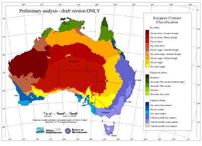 |
| Figure 4. Climatic classification of Australia based on the Koeppen scheme of vegetation suitability derived by the Bureau of Meteorology in 1998. (enlargement) |
BoM81:
Bom81 represents the climatic zones derived from rainfall and temperature data and defined by the Bureau of Meteorology in 1981 (Figure 5).
This field is a category field and utilises a picklist (Table 10).
| Table 10. BoM81 codes and description. | ||
|---|---|---|
| Number | Code | Classification |
| 1 | SRT | Summer Rainfall - Tropical |
| 2 | SRS | Summer Rainfall - Subtropical |
| 3 | URT | Uniform Rainfall - Temperate |
| 4 | WRTh | Winter Rainfall - Temperate |
| 5 | WRTm | Winter Rainfall (mod-heavy) - Temperate |
| 6 | SAS | Arid (mainly summer rainfall) - Subtropical |
| 7 | WASwt | Arid (winter -non-seasonal rain) - Warm Temperate to Subtropical |
 |
| Figure 5. Climatic zones of Australia derived by the Bureau of Meteorology in 1981. (enlargement) |
IBRA:
The Interim Terrestrial Biogeographic Regionalisation of Australia (IBRA), comprises eighty `natural' regions, of which thirty five regions are coastal (Figure 6). It provides an agreed integrated regionalisation of Australia's broad ecosystems or �natural� regions. IBRA was derived by compiling the best available continental scale data and information for each State and Territory, including field knowledge, published reports, and biogeographic regionalisations for each State and Territory (Thackway & Cresswell, 1995).
This field is a category field and utilises a picklist (Table 11).
| Number | Code | Name |
| 1 | NCP | Naracoorte Coastal Plain |
| 2 | VVP | Victorian Volcanic Plain |
| 3 | SCP | South East Coastal Plain |
| 4 | SEH | South Eastern Highlands |
| 5 | SEC | South East Corner |
| 6 | BEN | Ben Lomond |
| 7 | TM | Tasmanian Midlands |
| 8 | FRE | Freycinet |
| 9 | WSW | West and South West |
| 10 | DE | D'Entrecasteaux |
| 11 | SB | Sydney Basin |
| 12 | BBN | North Brigalow |
| 13 | NNC | NSW North Coast |
| 14 | GAW | Gawler |
| 15 | EYB | Eyre and Yorke Blocks |
| 16 | LB | Lofty Block |
| 17 | GUP | Gulf Plains |
| 18 | CYP | Cape York Peninsula |
| 19 | WT | Wet Tropics |
| 20 | CMC | Central Mackay Coast |
| 21 | VB | Victoria Bonaparte |
| 22 | CAR | Carnarvon |
| 23 | ESP | Esperance Plains |
| 24 | DL | Dampierland |
| 25 | WAR | Warren |
| 26 | NK | Northern Kimberley |
| 27 | GS | Geraldton Sandplains |
| 28 | PIL | Pilbara |
| 29 | SWA | Swan Coastal Plain |
| 30 | GUC | Gulf Coastal |
| 31 | SEQ | South Eastern Queensland |
| 32 | BBS | South Brigalow |
| 33 | CA | Central Arnhem |
| 34 | TEC | Top End Coast |
| 35 | WOO | Woolnorth |
| Source: (Thackway & Cresswell, 1995) | ||
 |
| Figure 6. The Interim Terrestrial Biogeographic Regionalisation of Australia - IBRA (Thackway & Cresswell, 1995). (enlargement) |
IMCRA:
The Interim Marine and Coastal Regionalisation of Australia (IMCRA) is being developed by the Interim Marine and Coastal Regionalisation for Australia Technical Group (IMCRATG) which is made up of Commonwealth, States and Northern Territory marine management and research agencies. IMCRA comprises of sixty meso-scale regions of which forty four are coastal. These regions are generally a continuous, narrow segmented band around the continent (Figure 7). The boundary between regions usually extends perpendicular to the coast line. This pattern is varied in shallow subtropical and tropical waters where several parallel bands extend out from the coast, in the vicinity of the North West Shelf and the Great Barrier Reef. (IMCRATG, 1997).
This field is a category field and utilises a picklist (Table 12).
| Table 12. IMCRA codes and names. | |||||
|---|---|---|---|---|---|
| Number | Code | Name | Number | Code | Name |
| 1 | SCT | Shoalwater Coast | 23 | EYR | Eyre |
| 2 | LMC | Lucinda-Mackay Coast | 24 | NSG | North Spencer Gulf |
| 3 | WTC | Wet Tropic Coast | 25 | SGF | Spencer Gulf |
| 4 | ECY | East Cape York | 26 | SVG | St Vincent Gulf |
| 5 | WCY | West Cape York | 27 | COR | Coorong |
| 6 | WLY | Wellesley | 28 | OTW | Otway |
| 7 | PEL | Pellew | 29 | BGS | Boags |
| 8 | GRO | Groote | 30 | DAV | Davey |
| 9 | AWS | Arnhem Wessel | 31 | BRU | Bruny |
| 10 | EMB | Eighty Mile Beach | 32 | FRT | Freycinet |
| 11 | ANB | Anson | 33 | FLI | Flinders |
| 12 | CAB | Cambridge - Bonaparte | 34 | CVA | Central Victoria |
| 13 | KIM | Kimberley | 35 | TWO | Twofold Shelf |
| 14 | KSD | King Sound | 36 | BAT | Batemans Bay Shelf |
| 15 | CAN | Canning | 37 | HAW | Hawkesbury Shelf |
| 16 | PIN | Pilbara (nearshore) | 38 | MAN | Manning Shelf |
| 17 | ZUY | Zuytdorp | 39 | TMN | Tweed-Moreton |
| 18 | SBY | Shark Bay | 40 | FRA | Franklin |
| 19 | CWC | Central West Coast | 41 | COB | Cobourg |
| 20 | LNE | Leeuwin-Naturaliste | 42 | KAN | Karumba-Nassau |
| 21 | WSC | WA South Coast | 43 | VDG | Van Dieman Gulf |
| 22 | MUR | Murat | 44 | VES | Victorian Embayments |
| Source: (IMCRATG, 1997) | |||||
 |
| Figure 7. The Interim Marine and Coastal Regionalisation for Australia: Meso-scale regionalisation (IMCRATG, 1997). (enlargement) |
The initial step in classifying Australian estuaries into physical types was to devise a categorisation of estuaries based on morphological attributes. This needed to be easily applied to all estuaries and result in the separation of estuaries into distinctive morphological groups.
Categorisation is based on recording information on the estuary mouth, the main drainage lines (MDL), the main water-body of the estuary, and the terminal drainage lines (TDL). TDLs are defined as terminating drainage lines or tributaries that are located within the estuarine drainage area and are predominantly of an estuarine nature.
A preliminary analysis of 100 estuaries selected from the AED was undertaken. The various physical components were identified by manual interpretation of the patterns produced by the high tide lines of the estuary and adjacent coast using image maps produced by Bucher and Saenger (1989) and 1:100000 topographic maps.
The physical components that have been identified include:
Mouth type - Single or Multiple mouth.
Mouth constriction - Constricted or Unconstricted. Constrictions were identified as having a convergence of opposing banks at or near the mouth. No distinction was made between natural or engineered constrictions. Unconstricted mouths were identified as having either parallel or diverging opposing banks (Figure 8).
 |
| Figure 8. Constricted (a and b) and Unconstricted (c and d) mouths. (enlargement) |
Branching of the MDLs - Branched or Unbranched. Branched MDLs ranged from a single branched waterbody comprising of cutoff loops, split channels to complex anabranching (Figure 9).
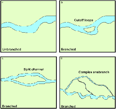 |
| Figure 9. Unbranched (a) and Branched (b, c and d) MDLs. (enlargement) |
MDL type - Channel or Bay. Channel MDLs were identified as having patterns with a consistent narrow width relative to their length, eg. riverine systems and small inlets. Bay MDL patterns were wider and/or irregular relative to their length, eg. bays, rias, and enclosed waters. Enclosed waters may include separate estuaries (Figure 10).
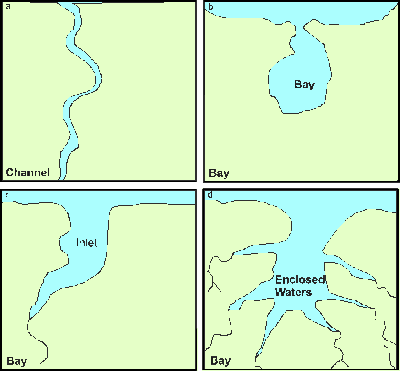 |
| Figure 10. Channel (a) and Bay (b, c and d) MDLs. (enlargement) |
Off-channel embayments - Present or Absent. Off-channel embayments were defined as being bay-like water-bodies that are distinctly separate from the MDL (Figure 11).
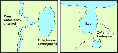 |
| Figure 11. Off-channel embayments (enlargement) |
Terminal Drainage Lines (TDLs) - 4 types - None, Single, Dendritic, or Single and Dendritic combination. The term dendritic refers to all branching drainage patterns such as digitate and parallel (Figure 12).
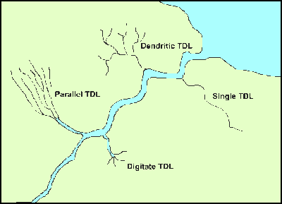 |
| Figure 12. Terminal Drainage Lines (TDL). (enlargement) |
The components of each estuary have been recorded in a multi-relational database table and a relational link to the AED was created. A dichotomous classification scheme, (Figure 13), was constructed from the first five components (TDL component was excluded) giving 32 possible categories of estuaries. Interrogation of the database indicated that 18 categories of estuaries were present in the 100 estuaries sampled.
These data were analysed with Primer v4.0 software using hierarchical clustering methods and the Bray-Curtis similarity coefficient. Present / Absent (Binary) matrices proved nonsensical and no clear clustering was apparent. Dichotomous matrices were compiled and various weightings were applied to the component values with no transformation. Clustering was successful only in separating multiple mouth, single constricted and single unconstricted mouthed estuaries at a similarity coefficient of ~83% when a weighting of 1 (single) and 4 (multiple) was allocated to the mouth types and 1 (constricted) and 3 (unconstricted) was allocated to the mouth constriction (Figure 14). Further weighting of the other estuarine components failed to improve the level of clustering.
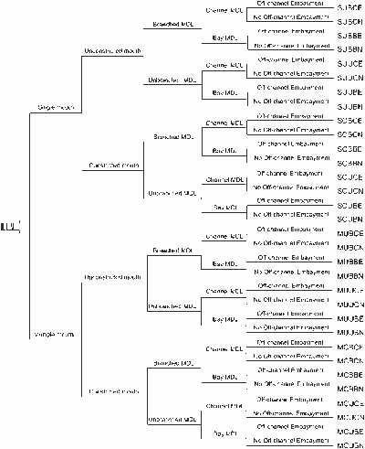 |
| Figure 13. Dichotomous classification scheme of the physical components used to derive the 32 possible physical categories of Australian estuaries. MDL refers to Main Drainage Lines or main water-body of the estuary. (enlargement) |
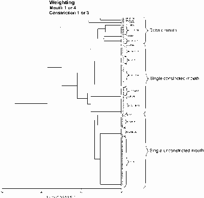 |
| Figure 14. A dendrogram showing clustering of the mouth components. (enlargement) |
The completion of the Morpho-Hydrological categorisation of Australian indicated that 28 categories are present out of a possible 32 (Table 13 and Figure 15). The spatial distribution of the six most abundant categories is shown in Figure 16.
| Table 13. Percentage frequency of Morpho-Hydrological categories present in Australian estuaries. | ||
|---|---|---|
| Morpho-Hydrological Code | Description | % Frequency |
| SUBCE | Single unconstricted mouth, branched channel with off-channel embayment | 1.0 |
| SUBCN | Single unconstricted mouth, branched channel with no off-channel embayment | 13.1 |
| SUBBE | Single unconstricted mouth, branched bay with off-channel embayment | 0.3 |
| SUBBN | Single unconstricted mouth, branched bay with no off-channel embayment | 4.1 |
| SUUCE | Single unconstricted mouth, unbranched channel with off-channel embayment | 1.2 |
| SUUCN | Single unconstricted mouth, unbranched channel with no off-channel embayment | 27.9 |
| SUUBE | Single unconstricted mouth, unbranched bay with off-channel embayment | 0.6 |
| SUUBN | Single unconstricted mouth, unbranched bay with no off-channel embayment | 8.5 |
| SCBCE | Single constricted mouth, branched channel with off-channel embayment | 2.3 |
| SCBCN | Single constricted mouth, branched channel with no off-channel embayment | 4.0 |
| SCBBE | Single constricted mouth, branched bay with off-channel embayment | 1.0 |
| SCBBN | Single constricted mouth, branched bay with no off-channel embayment | 1.7 |
| SCUCE | Single constricted mouth, unbranched channel with off-channel embayment | 1.3 |
| SCUCN | Single constricted mouth, unbranched channel with no off-channel embayment | 6.5 |
| SCUBE | Single constricted mouth, unbranched bay with off-channel embayment | 2.9 |
| SCUBN | Single constricted mouth, unbranched bay with no off-channel embayment | 5.1 |
| MUBCE | Multiple unconstricted mouth, branched channel with off-channel embayment | 0.5 |
| MUBCN | Multiple unconstricted mouth, branched channel with no off-channel embayment | 7.2 |
| MUBBE | Multiple unconstricted mouth, branched bay with off-channel embayment | 0.9 |
| MUBBN | Multiple unconstricted mouth, branched bay with no off-channel embayment | 2.4 |
| MUUCE | Multiple unconstricted mouth, unbranched channel with off-channel embayment | 0.3 |
| MUUCN | Multiple unconstricted mouth, unbranched channel with no off-channel embayment | 3.8 |
| MUUBE | Multiple unconstricted mouth, unbranched bay with off-channel embayment | 0.1 |
| MUUBN | Multiple unconstricted mouth, unbranched bay with no off-channel embayment | 1.9 |
| MCBCE** | Multiple constricted mouth, branched channel with off-channel embayment** | 0.0 |
| MCBCN | Multiple constricted mouth, branched channel with no off-channel embayment | 0.3 |
| MCBBE | Multiple constricted mouth, branched bay with off-channel embayment | 0.4 |
| MCBBN | Multiple constricted mouth, branched bay with no off-channel embayment | 0.1 |
| MCUCE** | Multiple constricted mouth, unbranched channel with off-channel embayment** | 0.0 |
| MCUCN | Multiple constricted mouth, unbranched channel with no off-channel embayment | 0.3 |
| MCUBE** | Multiple constricted mouth, unbranched bay with off-channel embayment** | 0.0 |
| MCUBN | Multiple constricted mouth, unbranched bay with no off-channel embayment | 0.3 |
| ** Category not present in Australia | ||
 |
| Figure 15. Frequency of Morpho-Hydrological Categories of Australian Estuaries. (enlargement) |
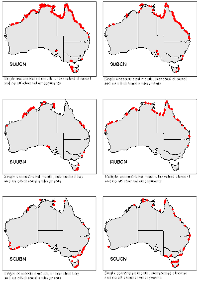 |
| Figure 16. The spatial distribution of the six most abundant Morpho-Hydrological categories of Australian estuaries. (enlargement) |
The objective of statistical analysis was to define a physical classification model that would explain as much of the variability in the proportion of mangroves and saltmarsh in the estuary as possible.
A secondary objective was to produce a classification scheme that did not divide the estuaries into too many classes because a scheme, that produced a large number of classes with few estuaries, would be of little value. As a consequence, some of the data in the estuary database were not used in the final classification system. On the other hand, as the estuary database contains more data than the classification requires, it offers users the ability to divide estuaries into additional classes based on factors that were not considered in the scheme presented here.
Mangrove and saltmarsh proportions were used for a national classification scheme because they were biological parameters that are easily measured are present in many estuaries and are relatively stable on a seasonal basis and from year-to-year (unlike seagrasses). Mangroves and saltmarshes are important habitats and their contribution to primary productivity will in part determine the type of trophic relationships that can exist in the estuary and the range of animal life it can support.
SPSS for Windows (Version 9.5.1.) was used for all statistical analyses. A combination of General Linear Modelling and Analysis of Variance was used to classify the estuaries. The proportion of mangroves, seagrass and saltmarsh were used as dependent variables but, the seagrass proportion was subsequently omitted because only 20% of the estuaries had seagrass areas recorded and the reliability of those records was questionable. A general linear model was used to determine which independent factors influenced changes in saltmarsh and mangrove proportions. A complex model incorporating all interactions was used. A factor/interaction was considered to be not significant if the probability of Type I error (a) was greater than 0.05. Any interaction that was not significant was omitted from the model and the change in the significance of the remaining factors noted. Five independent variables were used; these are described below. The classification was undertaken in eight stages (Figure 17).
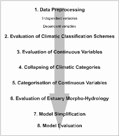 |
| Figure 17. A flow diagram of the eight stages of the classification process. (enlargement) |
Of the 780 estuaries in the database 22 were excluded from the analysis because they were composite estuaries that were represented by their component estuaries. For example, Darwin Harbour was excluded, but the five individual estuaries that make up Darwin Harbour were included (Figure 3). A further 135 estuaries were excluded because the information needed for classification was not available. The remaining 623 estuaries were used in the analysis.
Climate zones
Symbol: BoM81 and BoM98
Description: Two Bureau of Meteorology climate zoning systems were compared. BoM81 consisted of 7 climatic zones (Figure 5). BoM98 consisted of 14 coastal climatic zones and was based on the Koeppen system (Figure 6).
Fluvial flow
Symbol: FF and Ffcat
Description: Fluvial flow, derived from the volume of fresh water draining to the river, is a function of catchment area, rainfall and runoff coefficient. Use of fluvial flow thus integrates these three factors into a single variable. Division by the open water area of an estuary allows a rough standardisation of freshwater flow per unit of estuary area over a range of estuary sizes. Fluvial flow is a continuous variable calculated using the formula below.
![]()
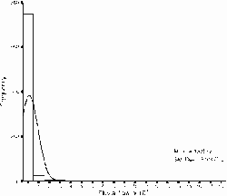
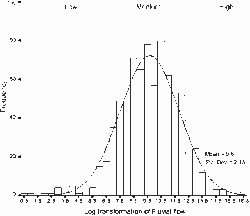
Fluvial flow was not normally distributed (Figure 18) and was normalised by using a natural log transformation. Fluvial flow was divided into three classes, based on the frequency distribution (low, medium and high) to create FFcat (Figure 19).
Low: | FF < mean FF - one standard deviation. |
Medium: | FF ³ mean FF - one standard deviation and £mean + one standard deviation. |
High: | FF > mean FF + one standard deviation. |
 (enlargement) |
 (enlargement) |
| Figure 18. The variable Fluvial Flow was transformed using Log e(Ln) | |
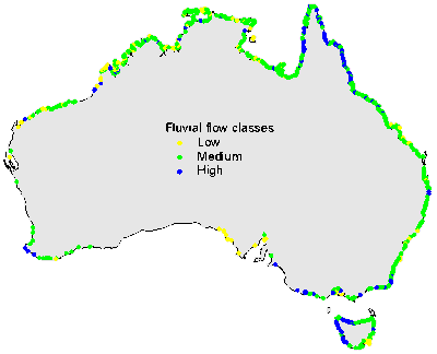 |
| Figure 19. The geographical distribution of fluvial flow categories. (enlargement) |
Low: | ITP < 0.33. |
Medium: | ITP ³ 0.33 and < 0.66 |
High: | ITP ³ 0.66 |
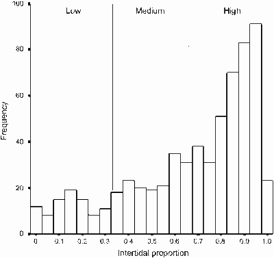 |
| Figure 20. Frequency histogram of intertidal proportion. (enlargement) |
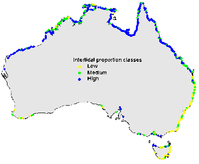 |
| Figure 21. The geographical distribution of intertidal proportion categories. (enlargement) |
| Low: | TR < 4 m |
| Medium: | TR ³ 4 m and < 8 m |
| High: | TR ³ 8 m |
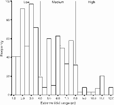 |
| Figure 22. Frequency histogram of extreme tidal range. (enlargement) |
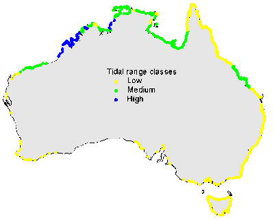 |
| Figure 23. The geographical distribution of tidal range categories. (enlargement) |
Mangrove proportion
Symbol: PM
Description: Mangrove proportion is the area of mangroves in an estuary divided by the total high-tide area of the estuary.
Seagrass proportion
Symbol: PSG
Description: Seagrass proportion is area of seagrasses in an estuary divided by the total high-tide area of the estuary. The proportion of seagrasses was not used further in the analysis because accurate data on seagrass area are available for only a few estuaries.
Saltmarsh proportion
Symbol: PSM
Description: Saltmarsh proportion is area of Saltmarsh in an estuary divided by the total high-tide area of the estuary.
The initial objective was to determine which climate zoning system would explain more of the variance in the dependent variables. The 1998 scheme (BoM98) divided the continent into 14 zones, whereas the 1981 scheme (BoM81) consisted of seven climatic zones. The 1981 system was preferred because it had fewer classes and would result in a simpler classification system. A model with all interactions using BoM81, TR, ITP, FF and all interaction terms was generated (Test 1.0, Table 14). The same model using BoM98 generated a model that explained about 18% more of the variance in mangrove and saltmarsh proportion (Test 2.0, Table 14). As a result, BoM98 was used in later analysis.
The next objective was to determine which of the continuous variables (FF, ITP and TR) made a significant contribution to the model. It was expected that the model would explain more of the variance in the mangrove and saltmarsh proportions if continuous variables were used. The full model was used and any interactions that were not significant were subsequently omitted. The revised model was evaluated and non-significant main effects were omitted (Test 2.1 and Test 2.2, Table 14).
The objective at this stage was to determine if any of the climatic zones could be amalgamated. BoM98 consisted of 14 zones. If all climatic zones were used the classifier would create too many classes with similar mangrove and saltmarsh proportions. Firstly, any zones with less than five estuaries were amalgamated with other similar climatic zones. Subsequently, analysis of variance was used to identify differences in mangrove and saltmarsh proportions between different climatic zones (Table 15). Post hoc tests (Tukey HSD) showed that the fourteen zones could be collapsed onto five broader zones (Tables 16 and 17). The model was re-evaluated with the amalgamated zones (Tests 3.0 - 3.2, Table 14) and the continuous variables were reassessed as in Stage Three (above). Collapsing the climatic zones from 14 to 5 resulted in a 0.006 decrease in r2 (Table 14), a reduction deemed to be insignificant.
The next objective was to divide the continuous variables (FF, ITP and TR) into three broad classes (Low, Medium and High). When the model was recalculated mangrove proportion r2 increased from 0.443 to 0.453 (Test 4.1, Table 14) and FF was no longer a significant factor in the model (Tests 4.0 and 4.1, Table 14).
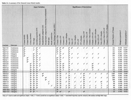 |
| Table 14. A summary of the General Linear Model results (enlargement) |
| Table 15. Results of Analyses of Variance comparing mangrove proportion and saltmarsh proportion within different BoM98 climatic zones. | ||||||
|---|---|---|---|---|---|---|
ANOVA |
|
Sum of |
|
|
|
|
|
|
Squares |
df |
Mean Square |
F |
Sig. |
Mangrove proportion |
Between Groups |
17.115 |
11 |
1.5560 |
30.6 |
0.000 |
|
Within Groups |
31.020 |
611 |
0.0508 |
|
|
|
Total |
48.135 |
622 |
|
|
|
|
|
|
|
|
|
|
Saltmarsh proportion |
Between Groups |
18.752 |
11 |
1.7050 |
24.9 |
0.000 |
|
Within Groups |
41.813 |
611 |
0.0684 |
|
|
|
Total |
60.564 |
622 |
|
|
|
| Table 16. Mean mangrove proportion in estuaries belonging to different BoM98 climatic zones. | |||||||
|---|---|---|---|---|---|---|---|
|
Means for groups in homogenous subsets (alpha = 0.05) |
||||||
Climatic zone (BoM 98) |
N |
1 |
2 |
3 |
4 |
5 |
Revised zone |
Temperate dry warm summer |
8 |
0.049 |
|
|
|
|
Temperate |
Temperate uniform rainfall - warm summer |
69 |
0.093 |
|
|
|
|
Temperate |
Dry hot steppe - Winter drought |
47 |
0.104 |
|
|
|
|
Hot dry |
Dry hot desert - Summer drought |
28 |
0.158 |
0.158 |
|
|
|
Hot dry |
Temperate dry hot summer |
9 |
0.232 |
0.232 |
0.232 |
|
|
Hot dry |
Dry hot steppe - Summer drought |
53 |
0.291 |
0.291 |
0.291 |
|
|
Hot dry |
Tropical Savannah - Wet Autumn |
213 |
|
0.424 |
0.424 |
0.424 |
|
Tropical Savannah |
Temperate uniform rainfall - hot summer |
90 |
|
|
0.445 |
0.445 |
|
Subtropical |
Temperate dry winter - hot summer |
16 |
|
|
0.488 |
0.488 |
|
Tropical |
Tropical Savannah - Wet Autumn - Uniform temp |
73 |
|
|
|
0.568 |
0.568 |
Tropical |
Dry warm steppe - Summer drought |
14 |
|
|
|
0.668 |
0.668 |
Subtropical |
Tropical Monsoon |
3 |
|
|
|
|
0.777 |
Tropical |
| Table 17. Mean saltmarsh proportion in estuaries belonging to different BoM98 climatic zones. | |||||||
|---|---|---|---|---|---|---|---|
|
Means for groups in homogenous subsets (alpha = 0.05) |
||||||
Climatic zone (BoM 98) |
N |
1 |
2 |
3 |
4 |
5 |
Revised zone |
Tropical Monsoon |
3 |
0.032 |
|
|
|
|
Tropical |
Temperate dry winter - hot summer |
16 |
0.188 |
0.188 |
|
|
|
Tropical |
Dry warm steppe - Summer drought |
14 |
0.189 |
0.189 |
|
|
|
Subtropical |
Temperate dry warm summer |
8 |
0.198 |
0.198 |
|
|
|
Temperate |
Temperate uniform rainfall - hot summer |
90 |
0.249 |
0.249 |
0.249 |
|
|
Subtropical |
Tropical Savannah - Wet Autumn - Uniform temp |
73 |
0.270 |
0.270 |
0.270 |
|
|
Tropical |
Temperate uniform rainfall - warm summer |
69 |
|
0.351 |
0.351 |
|
|
Temperate |
Tropical Savannah - Wet Autumn |
213 |
|
0.444 |
0.444 |
0.444 |
|
Tropical Savannah |
Temperate dry hot summer |
9 |
|
0.450 |
0.450 |
0.450 |
|
Hot dry |
Dry hot steppe - Summer drought |
53 |
|
|
0.565 |
0.565 |
0.565 |
Hot dry |
|
Dry hot desert - Summer drought |
28 |
|
|
|
0.674 |
0.674 |
Hot dry |
Dry hot steppe - Winter drought |
47 |
|
|
|
|
0.849 |
Hot dry |
The objective at this stage was to determine whether CatBREM could further improve the reliability of the model. The value of r2 increased when CatBREM was incorporated into the model but the potential number of classes increased from 45 to 1305 (Tests 4.1 and 5.1, Table 14). Channel branching and presence or absence of embayments was omitted from the CatBREM classes to reduce the number of classes by a factor of four (Tests 6.0 and 6.1, Table 14). Finally, each of the individual morpho-hydrological characteristics were assessed to determine if they helped classify the estuary. None of the factors proved to be statistically significant and CatBREM was subsequently omitted from the model (Tests 7.0 - 7.0, Table 14).
At this stage the objective was to reduce the potential number of classes from 45 to less than 30. The model had the potential to divide the estuaries into 45 classes and to explain 45% and 42% of the variation of mangrove and saltmarsh proportions, respectively (Test 4.1, Table 14). Reviewing the final classification showed that many estuaries with a low tidal range were divided on the basis of intertidal proportion. It was considered that ITP would have little independent influence on biological factors in these estuaries. Analysis of variance was used to test this hypothesis and revealed no significant difference in mangrove proportion (PM) or the saltmarsh proportion (PSM) in estuaries in the different ITP classes with a low tide range. If ITP was omitted from the model, r2 decreased by 0.07 (Test 10.0, Table14). However, omitting ITP as a factor for estuaries with a low tidal range and retaining it for estuaries with medium and high tidal range caused little change in r2 (Test 11, Table 14).
In the final classification estuaries were first classed into five groups based on climate. These classes were further divided into 15 groups based on tidal range. Of the 15 groups 11 contained estuaries (Figure 24). All estuaries with a mid- or high-tide range were further divided on the basis of intertidal proportion to make 23 classes and of these, 21 contained estuaries (Figure 25). The final model explained 44.5% and 42.1% of the variation in mangrove and saltmarsh proportions, respectively. A comparison of mouth type (single/multiple) and mouth constriction (constricted/unconstricted) was used to further divide estuaries with low tide range. However, no significant differences became apparent when these comparisons were made.
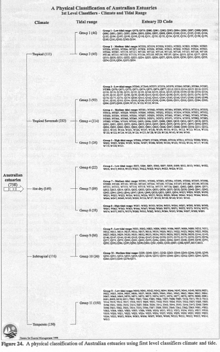 |
| Figure 24. A physical classification of Australian estuaries using first level classifiers climate and tide. (enlargement) |
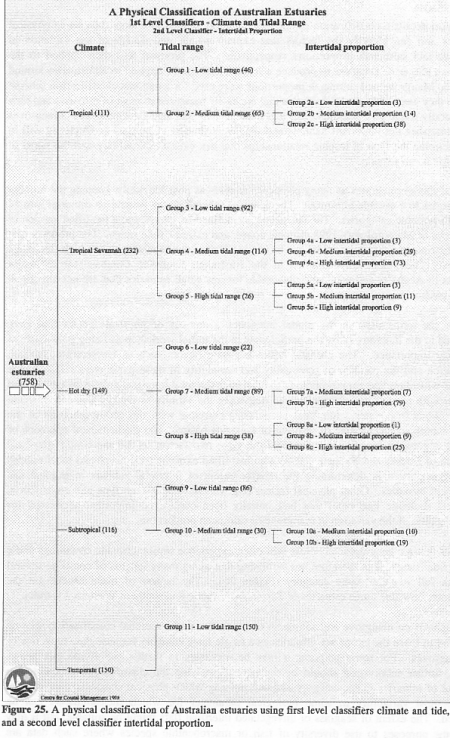 |
| Figure 25. A physical classification of Australian estuaries using first level classifiers climate and tide, and a second level classifier intertidal proportion. (enlargement) |
This report details a classification protocol that can be applied to a large data set of physical variables and can identify the factors that explain 44.5% and 42.1% of the variation in mangrove and saltmarsh proportions, respectively. The protocol was then applied to the Australian Estuarine Database to produce a scheme that can be applied to all estuaries around Australia. Mangrove and saltmarsh proportions were used for a national classification scheme because they were biological parameters that are easily measured in most of estuaries and they are generally stable on a seasonal basis and from year-to-year (unlike seagrasses). Mangroves and saltmarshes are important habitats and their contribution to primary productivity will in part determine the type of trophic relationships that can exist in the estuary and the range of animal life it can support.
The final model integrates as many physical variables as possible whilst keeping the number of categories to a useable minimum. The resultant scheme places Australian estuaries into 11 out of 15 possible categories. The categories are defined by two terms; a modified version of the Bureau of Meteorology's 1998 climatic zones, and extreme tidal range. The proportion of total estuarine area that is intertidal can be used to further divide moderate and high tide range estuaries. These data are contained in the Australian Estuarine Database for all major estuaries in Australia and are easily obtainable for any small estuaries that are not already in the database.
Each of the terms used in the model integrates a number of physical factors that were identified in the literature or by the participants in the initial workshop as being potentially of biological importance. The climatic zones integrate factors such as temperature, rainfall, evaporation and the patterns of seasonality and variability in these parameters. Tidal range interacts with shoreline geomorphology to determine the total intertidal area in an estuary and interacts with rainfall and evaporation to determine the salinity of the sediment at different heights above low water. Intertidal proportions correlate with the geomorphology of the estuary mouth and the degree of infilling of estuarine basins. The mathematical approach of multiple regression analysis has identified the same two factors as did the simple graphical approach of Bucher and Saenger (1994) who identified extreme tidal range and local rainfall as being important in determining the relative extent of intertidal habitats in tropical and subtropical estuaries. Other physical factors (e.g. fluvial flow, mouth type and constriction, and main drainage line type) that had initially been considered important accounted for relatively little of the variation in mangrove or saltmarsh proportions.
Estuaries that are geographically close will often experience similar climatic conditions and a similar tidal range. It is therefore not surprising that along many lengths of coastline several estuaries fall into the same category (Figure 26). The largest of these blocks are the Temperate, Low tide range estuaries of Tasmania, Victoria and southern Western Australia.
The emphasis on mangrove and saltmarsh communities in the national classification scheme does tend to leave the temperate estuaries as a single large category because they have few or no mangroves. For some purposes it may be necessary to further sub-divide this group. Ideally, further subdivision should be done by re-applying the classification protocol to a database of estuaries in the category and determining which physical characteristics account for the most variability in some biological parameter for which measurements can be obtained. The extent of seagrass or unvegetated intertidal flats might be suitable, but it may suit some purposes to use diversity of fish or macrobenthic species where such data are available for a sufficiently large sample of estuaries. In the absence of data on a suitable biological parameter, further subdivision could be achieved by arbitrarily selecting a term such as the morpho-hydrological categories or biogeographic provinces as a secondary classifier. However, there is no guarantee that this approach would divide the estuaries into groups that are biologically different from one another. The value of the model developed for this report is that it provides a methodology by which biologically-important physical factors can be identified.
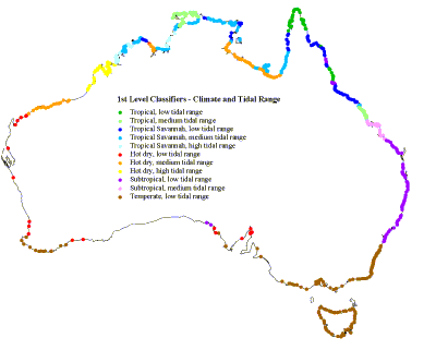 |
| Figure 26. The geographical distribution of estuaries in each of the eleven accepted classes using only the first level classifiers. (enlargement) |
| Dr John Anderson Centre for Coastal Management |
Karen Barton Catchment and Marine Studies Environment Protection Authority |
| Danny Bucher Centre for Coastal Management |
Malcom Clark Centre for Coastal Management |
| Peter Davies Project Officer Centre for Coastal Management |
Dr David Deeley Bicton WA 6157 |
| Dr Bill Dennison Dept of Botany University of Queensland |
Mike Digby Project Officer Centre for Coastal Management |
| Lisa Dixon Catchment and Marine Studies Environment Protection Authority |
Dr Bradley Eyre Senoir Lecturer in Biogeochemistry Centre for Coastal Management |
| Jennita Gay Centre for Coastal Management |
Dr Russell Hanley Director Hanley, Caswell and Associates Pty Ltd |
| Dr David Heggie Australian Geological Survey Organisation |
Dr Nick Holmes Senior Lecturer in Marine Biology and Coastal Resource Management Centre for Coastal Management |
| Dr Don Hough Marine and Coastal Policy Parks, Flora and Fauna Division |
Dr John Hunter Principle Research Scientist Division of Oceanography CSIRO |
| Geoff Kerr Centre for Coastal Management |
Greg Luker GIS Laboratory Manager Centre for Coastal Management |
| Assoc. Prof. David McConchie Senior Lecturer in Environmental Chemistry and Coastal Geomorphology Centre for Coastal Management |
Andrew Moss Queensland Dept of Environment |
| Dr John Parslow Research Scientist Marine Laboratories CSIRO |
Dr Gary Poore Senior Curator - Crustacea Dept of Natural Sciences Museum of Victoria |
| Dr Peter Roy Senior Research Scientist Geological Survey of NSW NSW Dept of Mineral Resources Dept of Geography University of Sydney |
Prof. Peter Saenger Centre Head Centre for Coastal Management |
| David van Sendon Consultant Manly Hydraulic Laboratory |
Michael Whelan Lecturer in Computing Centre for Coastal Management |
<TITLE>A Physical Classification of Australian Estuaries</TITLE>
<META NAME="DC.Title" CONTENT="A Physical Classification of Australian Estuaries">
<META NAME="DC.Creator" CONTENT="Digby, M.J., Saenger, P., Whelan, M.B., McConchie, D., Eyre, B., Holmes, N., and Bucher, D.">
<META NAME="DC.Type" CONTENT="text">
<META NAME="DC.Date" CONTENT="1999">
<META NAME="DC.Format" CONTENT="text/html">
<META NAME="DC.Coverage" CONTENT="Australia">
<META NAME="DC.Description" CONTENT="The objective of this project was to develop a national classification of Australian estuaries based on easily quantifiable biologically important physical characteristics, to enable valid comparisons between biotic communities of different estuaries">
<META NAME="DC.Relation" CONTENT="National River Health Program - Project E1 Project reference no: 4178 Centre for Coastal Management, Southern Cross University, Lismore, NSW 1998. This report describes the outcomes of a research project conducted under the Urban Research and Development sub-program of the National River Health Program (NRHP). The NRHP is an on-going national program established in 1993, managed by the Land and Water Resources Research and Development Corporation (LWRRDC) and Environment Australia. Its mission is to improve the management of Australia's rivers and floodplains for their long-term health and ecological sustainability.">
<META NAME="DC.Source" CONTENT="Environment Australia community Information Unit">
<META NAME="DC.Subject" CONTENT="Water, rivers">
<META NAME="DC.Publisher" CONTENT="Land and Water Resources Research and Development Corporation. GPO Box 2182 Canberra ACT 2601">
<META NAME="DC.Publisher" CONTENT="Published Electronically on au.riversinfo.org by the Environmental Information Association (Incorporated) with the permission of LWRRDC and Environment Australia.">
<META NAME="DC.Rights" CONTENT="Copyright (©) LWRRDC">
<META NAME="DC.Identifier" CONTENT="National River Health Program - Project E1 Project reference no: 4178 Centre for Coastal Management, Southern Cross University, Lismore, NSW 1998">
<META NAME="DC.Identifier" CONTENT="http://au.riversinfo.org/library/nrhp">
<meta name= "DC.Language" content = "en">
 Riversinfo Australia (au.riversinfo.org): Publication Information:
Current at December 2002
![]() au.riversinfo.org has been developed to facilitate public access to scientific and technical information on Australia's Rivers. Much of this material was paid for using public funds and is therefore owned by the Australian people. Environment Australia have been instrumental in making available all the publications from:
au.riversinfo.org has been developed to facilitate public access to scientific and technical information on Australia's Rivers. Much of this material was paid for using public funds and is therefore owned by the Australian people. Environment Australia have been instrumental in making available all the publications from:
 The au.riversinfo.org Internet site is in-part supported by the Natural Heritage Trust. The Natural Heritage Trust focuses on five key environmental themes - land, vegetation, rivers, coasts and marine, and biodiversity. The programs of the Natural Heritage Trust play a major role in developing sustainable agriculture and natural resource management, as well as protecting our unique biodiversity through improved management and delivery of resources.
 The au.riversinfo.org Internet site is in-part supported by Sydney Airport who have co-funded a Natural Heritage Trust supported project intended to develop Internet based environmental information integration and management systems. This will assist in developing an overall perspective on the demands and uses for environmental resources